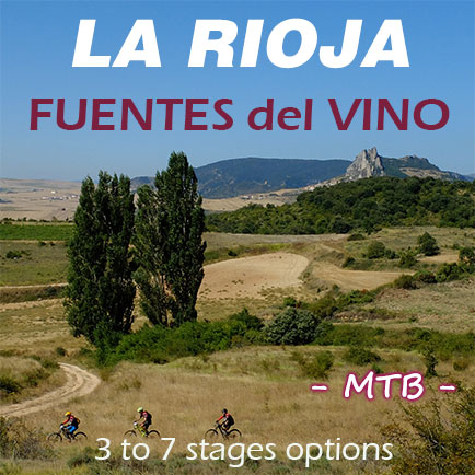
The Mountain Bike Route through the Wineyards and Mountains of LA RIOJA
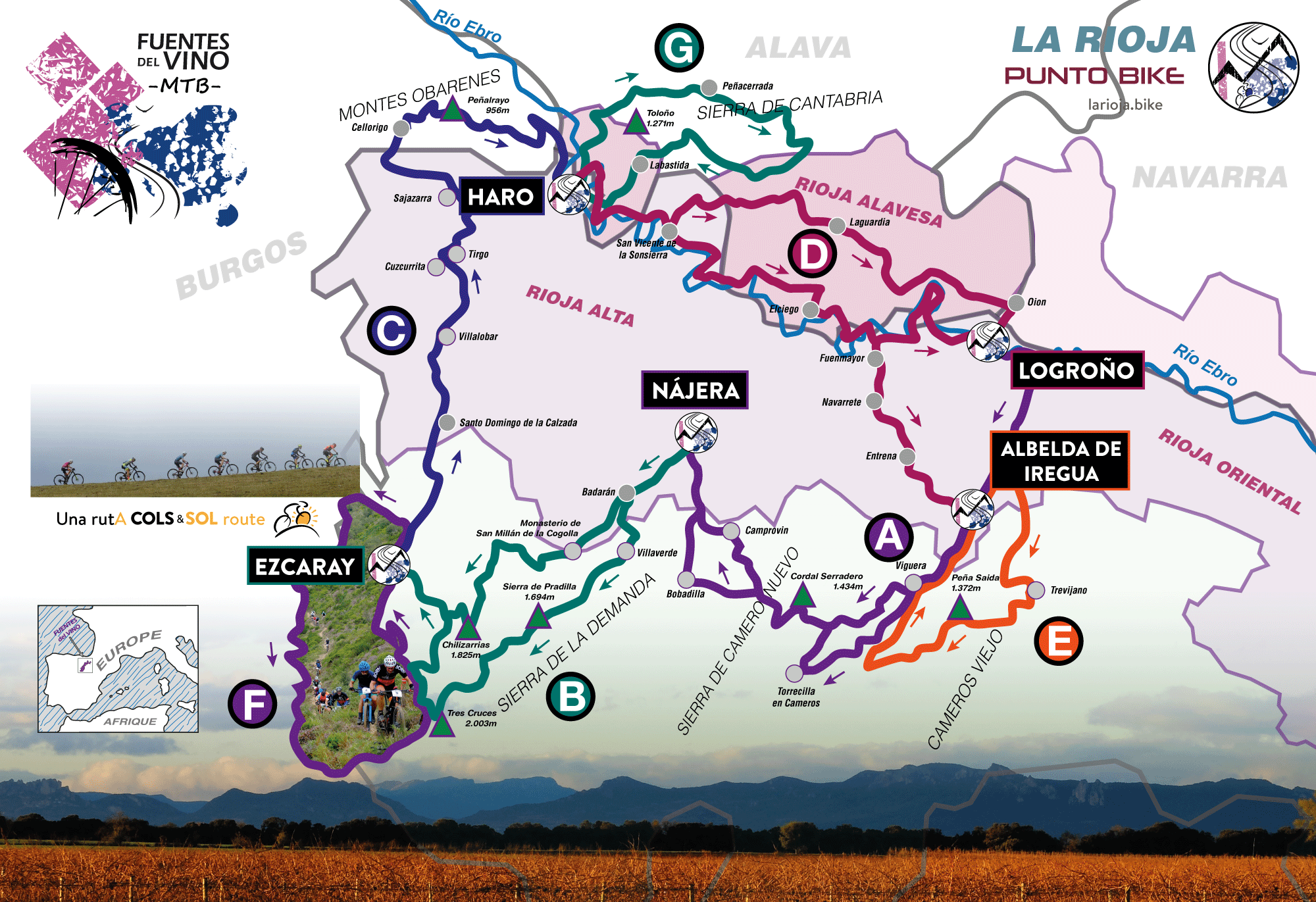
Three Ranges and a River, these are the geographical elements that, together with your mountain bike, give form to FUENTES del VINO MTB. Cameros Range, La Demanda Range, Cantabria Range -Montes Obarenes- and the Ebro River in the center articulating everything.
A simply overflowing and varied geography in which each stage prints its own personality.
Stage A, Portal de Cameros, American West environment between Islallana and Viguera - Camero Nuevo Range -
Stage B, the Ezcaray Extrem BTT sharing track with FUENTES del VINO MTB - La Demanda Range -
Stage C, Cellorigo and its Montes Obarenes on the plains of the Tirón River - Cantabria Range -
Stage D, Ebro River and Vineyards Sea- Baños de Ebro -
Stage B, Camino de los Serranos, demanding path if we have chosen the technical alternative of the route. In the background La Cuculla Peak - La Demanda Range -
Stage C, numerous sequences of "flow" in the Montes Obarenes - Cantabria Range -
Stage B, arrival at Collado de Marrulla - La Demanda Range -
Stage D, we continue in the Sea of Vineyards as we pass through El Cortijo. On the horizon, the Sierra de Cantabria - Ebro Basin -
.
The kilometers and the unevenness of the route obviously vary depending on the selection of stages we make. But these data from a "standard" selection are worth to give us an idea of the possible set:
FUENTES del VINO MTB 4 Stages A+B+C+D: Distance 254 km / Unevenness 4.915 m
FUENTES del VINO MTB TOTAL 7 Stages A+B+C+D+E+F+G: Distance 435 km / Unevenness 8.935 m
.
FUENTES del VINO MTB is the mountain bike route that will allow us in equal parts, navigate through the spectacular sea of La Rioja vineyards and ride along the trails of the Sierras that, like cliffs, fly over and feed this sea, the SOURCES of WINE.
The starting point of the route can be
...
both Logroño as Albelda de Iregua. The structure of FUENTES del VINO MTB is a base route with 4 point to point stages -A, B, C y D- and 3 optional circular stages -E, F and G- which, randomly combined with the first 4 allow up to a maximum of 7 stages.
Of the stages of the point to point alternative, we could say that they are essentially rolling, since the common denominator of all of them is a first section of small paved and unpaved roads which among crops and vineyards allow us to "eat kilometers" with relative ease and as if good gregarious ciclists were treated, they put us at the foot of the "wall" of the mountain range where we will have to manage alone.
Once up and except in the last stage - the Ebro River - in which the above is not met as we will not have "wall", in the other 3 stages we can choose depending on our style of "bikers" if we descend by tracks and essentially easy and rolling paths, or if we decide on the options, but harder, at least if more technical, All Mountain we could say. Those options sometimes by technical sections, and sometimes of authentic "flow" deposit us in the same end points of stage as those of the more rolling options.
These 3 minutes of video can help you understand what FUENTES del VINO MTB is
The Stages and the Tracks
Stage A
Stage B
Stage C
Stage D
Stage E
Stage F
Stage G
The structure of FUENTES del VINO MTB is a base route with 4 point to point stages -A, B, C y D- and 3 optional circular stages -E, F and G- which, randomly combined with the first 4 allow up to a maximum of 7 stages, then we speak of FUENTES del VINO TOTAL, an experience difficult to forget.
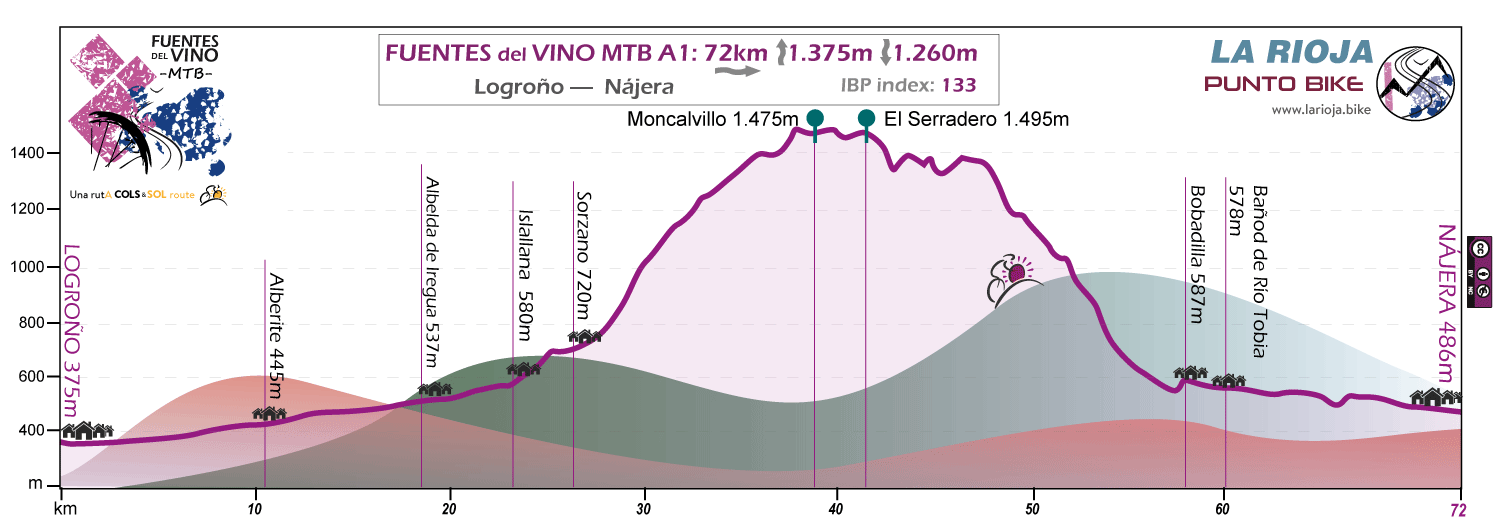
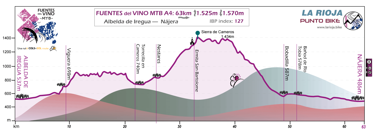
Stage A: Logroño / Albelda de Iregua - Nájera
Distance 72 / 63 km - Unevenness 1.375 / 1.505 m
FUENTES del VINO MTB can start in Logroño or in Albelda de Iregua. If we start the route in Logroño the stage is clearly divided into 2 sections, a first gently ascending part, between Logroño and Portal de Cameros, following the banks of the Iregua river, and a second part in which the crops and vineyards that have shaped the landscape until here give way to Sierra de Camero Nuevo with its mountain meadows and its cattle.
If we start the route in Albelda de Iregua the route includes an apparently "harmless" section between Viguera and Torrecilla in Cameros, the Calzada Romana del Iregua, which in this section becomes a fairly technical singletrack and demanding progress.
Stage B: Nájera - Ezcaray
Distance 60 / 47 / 54 km - Unevenness 1.875 / 1.700 / 1.900 m
In stage B we can choose between 3 route options. In any case, the route runs through a section monopolized by the vineyard first, to then face the "wall" of La Demanda Range until reaching - first crossing the demanding Pradilla Range - the 2003 meters of altitude in the surroundings of the Collado de Tres Cruces (B1) or the 1,825 of the Pico Chilizarrias if we choose option B2 - a little shorter - which ascends to the mountains through San Millan de la Cogolla, La Fonfria and Pazuengos.
In any case, from the top of La Demanda Range to Ezcaray, two of the best "flow" descents in La Rioja await us.
In Spring and if the snow prevents pedaling through the higher areas, we use the second option and we contour the Pico Chilizarrias on the North slope towards the Col de Marrulla.
The 3rd of the options (B3) is a geographically intermediate option between the other 2 but with more technical difficulty since it is developed through the 1,200 meters of descent from the Portillo de Nestaza to Ezcaray by the Camino de los Serranos in the first part of the descent and through one of the new sections of DH Enduro Ezcaray in the last section between Collado de Sagastia and Ezcaray. A "Down" of those who are not easily forgotten.
Stage C: Ezcaray - Haro
Distance 77 km - Unevenness 1.075 m
As in stages A and B, the first part of this stage starts crossing the Oja and El Tiron basins on flat terrain using small roads and paths among crops and vineyards. From Sajazarra the route begins to ascend towards Cellorigo, already located in the Cantabria Range, and from this point starts the path that will take us to Peñalrayo, the highest peak of the Obarenes Mountains with its 953 meters. It will be the moment to decide which option of the route we do, the one of easy pedaling or the technique.
After traversing a good section of the Montes Obarenes, always oriented towards the East, the 2 options converge at the Hermitage of San Felices and descend together until the famous "Barrio de la Estación" of Haro through the vineyards of Muga Wineries. The technical data is practically the same so we only show one of the profiles.
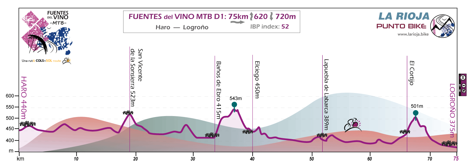
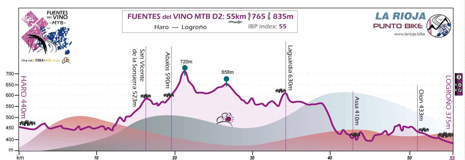
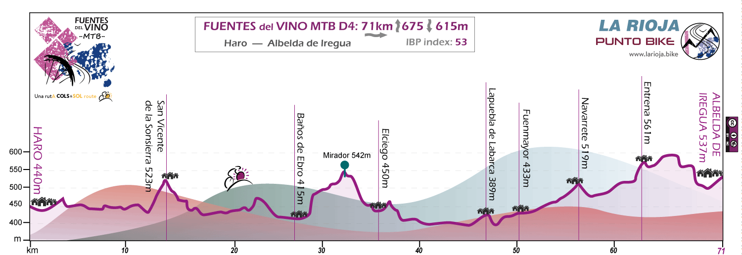
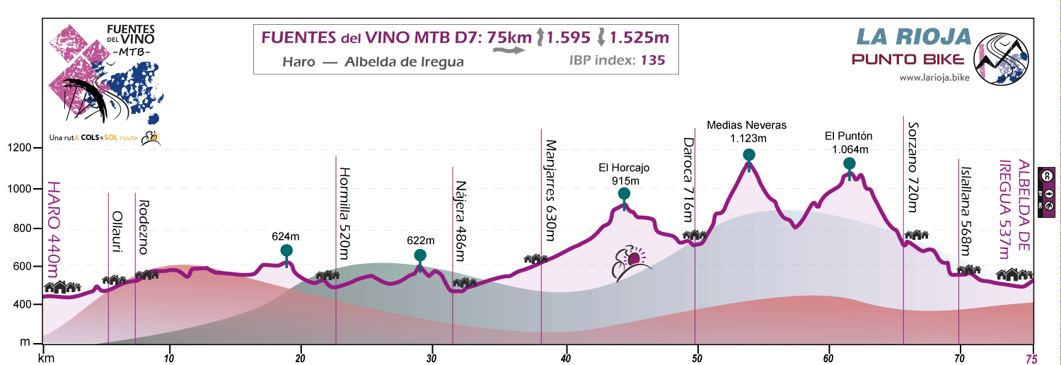
Stage D: Haro - Logroño / Albelda de Iregua
Distance 75 / 58 / 71 / 75 km - Unevenness 620 / 855 / 675 / 1.595 m
If FUENTES del VINO MTB was started in Logroño we have 2 options for this stage between Haro and the starting point. One through the Ebro Basin and the other through the Sierra de Cantabria slope.
Thus, if we go to Logroño, this last stage (D1) is undoubtedly "the Ebro stage", the old "Iber" which gave its name to the entire Iberian Peninsula. We will constantly pedal through vineyards through the meanders that shape the river in a continuous succession of monumental towns such as San Vicente de la Sonsierra, Baños de Ebro, Elciego or Lapuebla de Labarca.
Without any doubt the atmosphere will be "River and Wine" with vineyards, huts or guardaviñas and countless wineries scattered throughout the landscape among which undoubtedly we will be surprised by the spectacular "Guggenheim" building of Marqués de Riscal.
From San Vicente de la Sonsierra we can also choose the option of leaving the Ebro (D2) and going up the slopes of the Sierra de Cantabria to reach Logroño passing through Laguardia. An alternative about 20 kilometers shorter than the Ebro route and specially designed for those who need to use the same day to complete the stage and the journey back home.
If FUENTES del VINO MTB was started in Albelda de Iregua we can choose whether to return through a fast stage with a flat profile (D4) among the Ebro vineyards or by a more serious stage (D7) heading directly to Nájera and then go uphill through the Moncalvillo slope looking for the combination of the MTB trails developed by local bikers such as Medias Neveras and Senda del Molinero first and the Senda del Zorro later as the culmination and final icing of FUENTES del VINO MTB
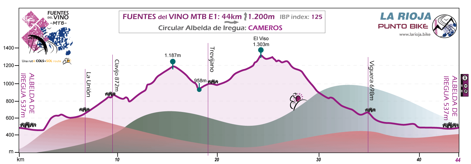
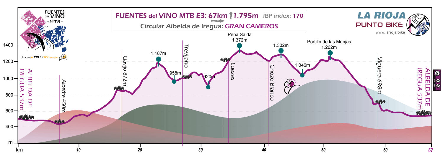
Stage E: Circular Albelda de Iregua
Distance 44 / 67 km - Unevenness 1.200 / 1.795 m
The 2 options that we give for this circular stage starting in Albelda de Iregua consist of 2 routes with the same philosophy but different difficulty. Both cross the mountains of the Sierra de Cameros, taking advantage of the many trails adapted for MTB by local bikers.
We are talking about a geography that is becoming internationally known for being the usual scenary of La Rioja BIKE RACE, the MTB stage race held annually in the area. The routes enter the Sierra de Cameros by the Senda de la Barguilla -de la Barriguilla in biker slang- they enter the paths of the neighboring Leza Valley, and ascending the peaks of El Viso or Peña Saida descend towards Viguera or Nalda linking several of the most popular singletrack trails in the area; Senda Preciosa, Aspero, Senda del Portillo de las Monjas ... Bonita ... del Monolíto ..
Gran Cameros is our proposal for road bikers to whom everything seems little.
Apart from the 2 options presented here, we have other more specific tracks with which we try to adapt the routes more if possible to the profiles of the cyclists.
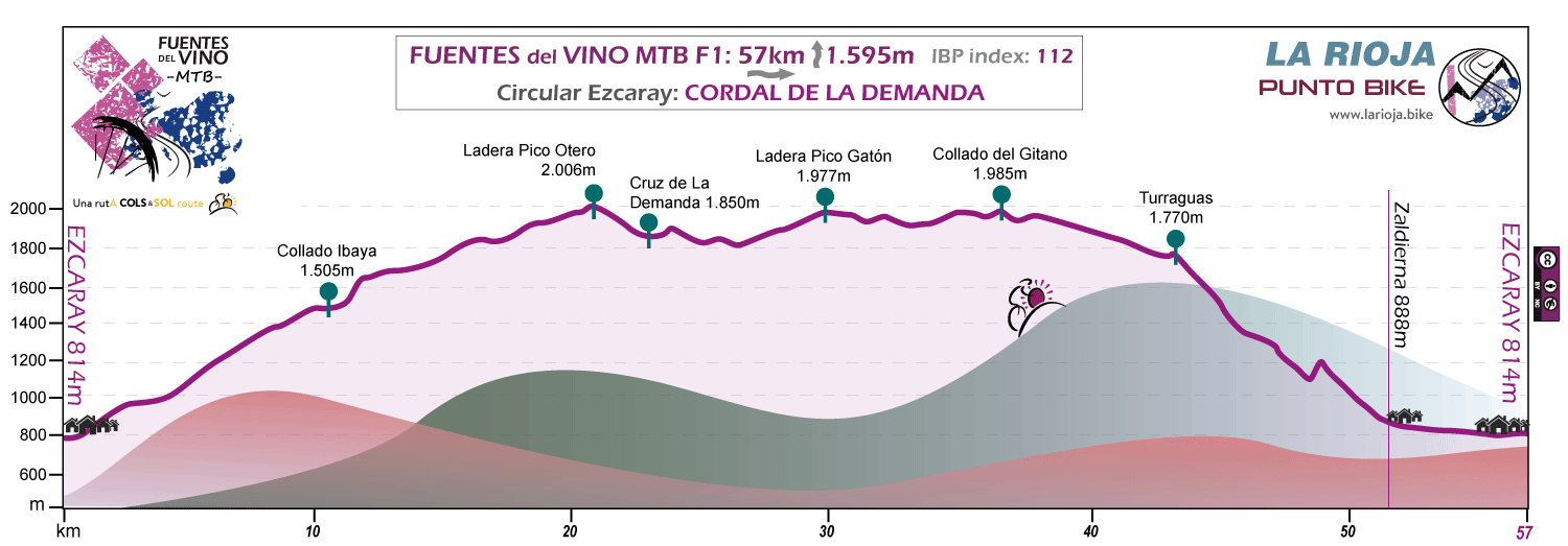
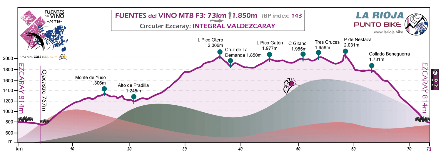
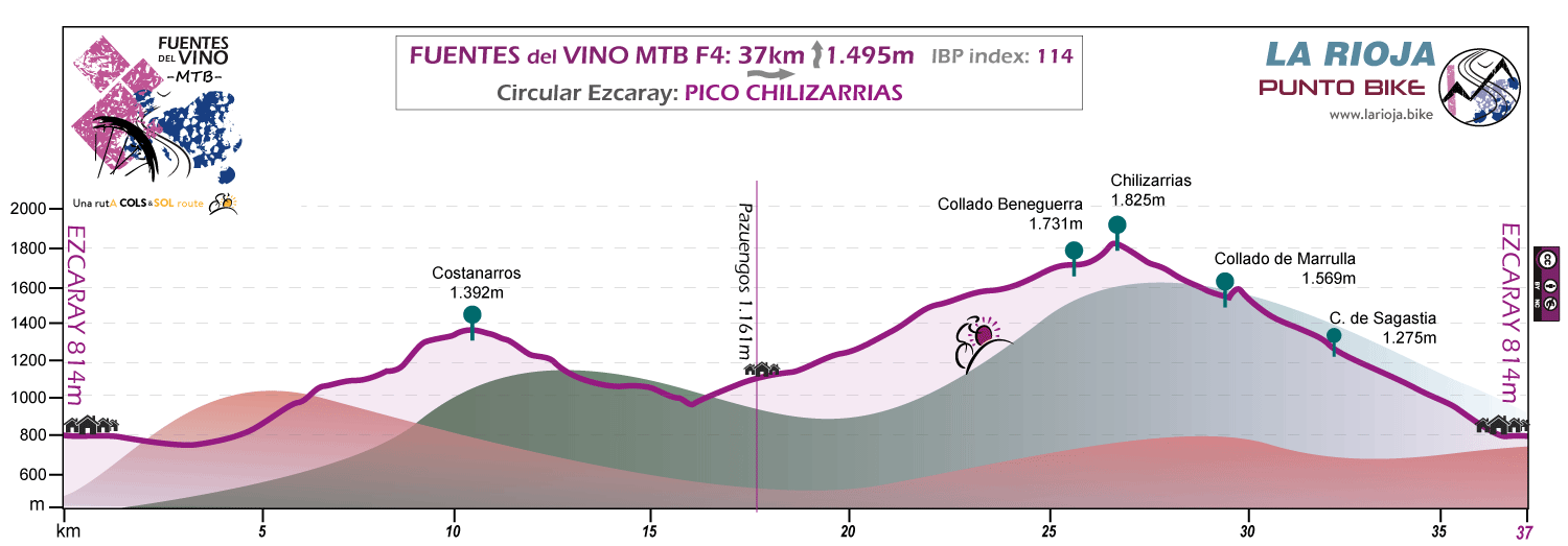
Stage F: Circular Ezcaray
Distance 57 / 73 / 37 km - Unevenness 1.595 / 1.850 / 1.495 m
For this circular stage from Ezcaray we can choose between 2 options of a geographical nature crossing the long mountain range of the Sierra de La Demanda, or a more playful option along the paths near the town.
In the first two (F1 and F3), we will pedal during a large section of the track on the border with Castilla and with the 2,000 meters of altitude at the top of the Atlantic-Mediterranean divide.
The Integral Valdezcaray option is a demanding proposal designed not to leave the "eaters" of kilometers without options.
The Pico Chilizarrias option (F4) is an opportunity to enjoy a somewhat more MTB and short stage, riding "singletrack" type paths in the geography closest to Ezcaray. A proposal to ensure an afternoon of rest and recovery.
VERMAPWIKI
Anyway, the selection of the stage will undoubtedly be conditioned by the route chosen the previous day. With a suitable choice we will avoid repeating geographic space.
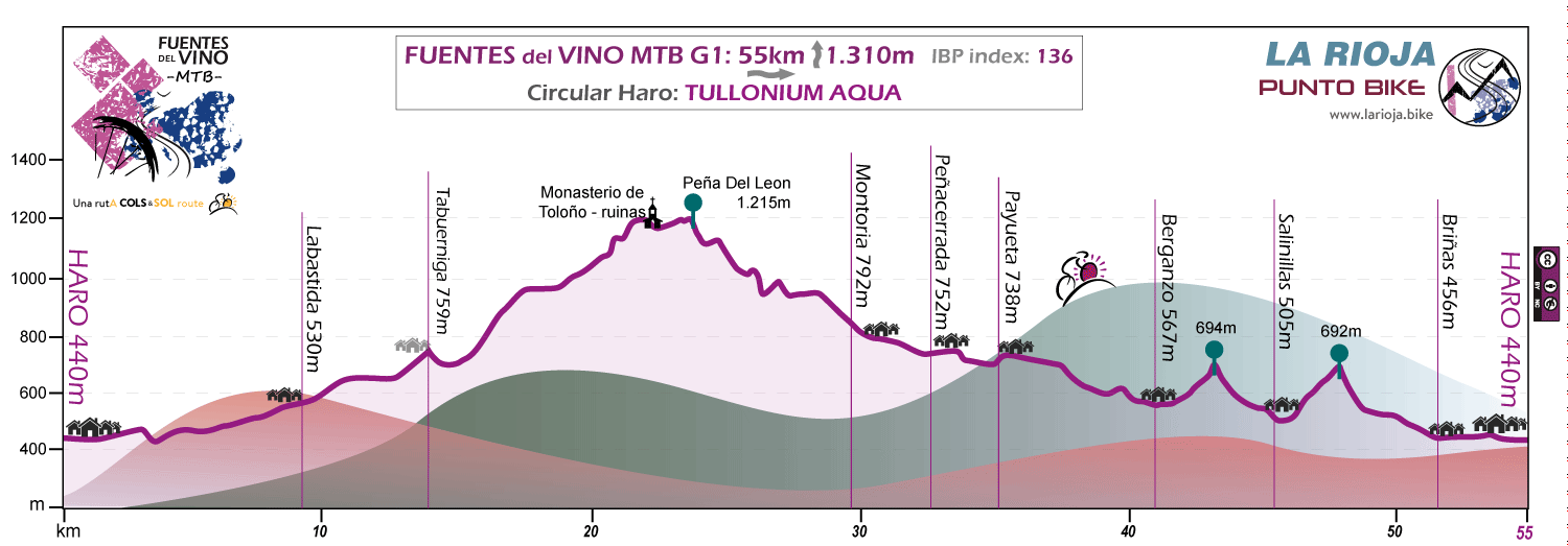
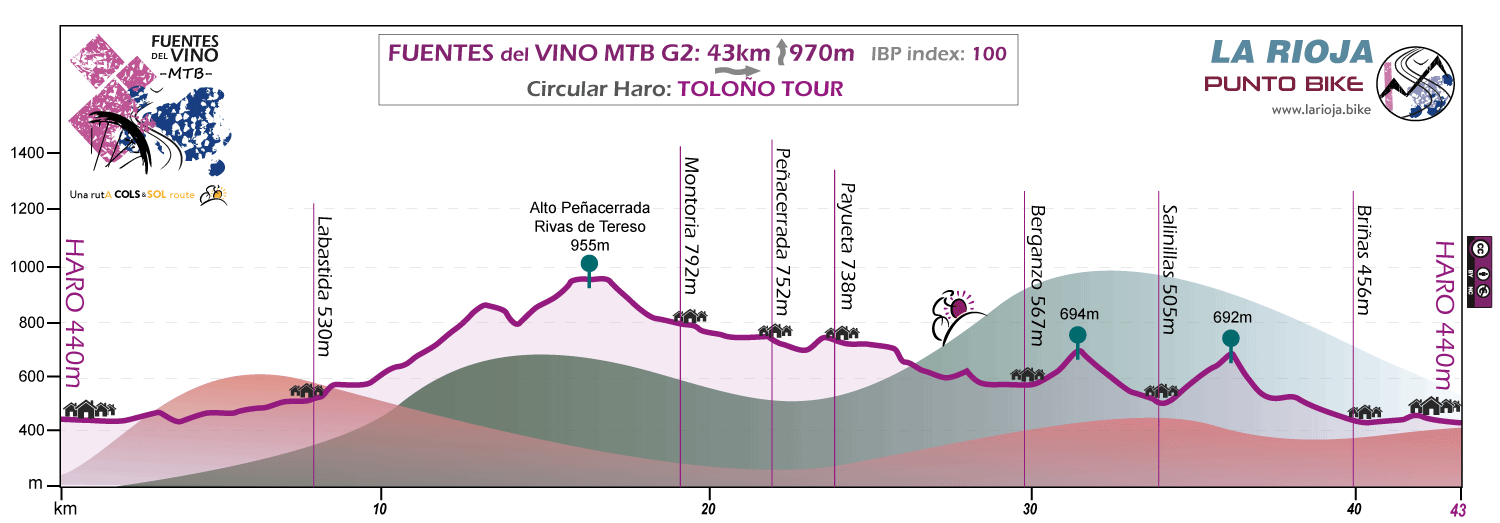
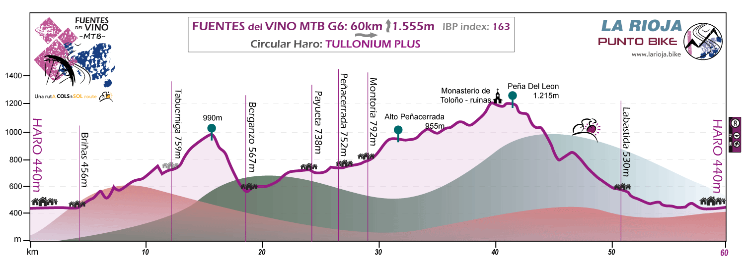
Stage G: Circular Haro
Distance 55 / 43 / 60 km - Unevenness 1.310 / 970 / 1.555 m
We call the proposed circular route of FUENTES del VINO MTB starting in HaroTULLONIUM because this is the Roman historians' reference to a god with whom the locals "negotiated" in the place before the implantation of Christianity.
The route ascends in the first part to the highest cyclable peak of the Toloño Massif, -although at some point you will surely have to push the bike- the Peña del León, and then heads out in search of the coolness, the beech trees and the vegetation of the North descending to Peñacerrada. Here the track lines up the Inglares River Valley, taking advantage of the well-traced "Sendero del Agua" -AQUA- which runs parallel to the river until it reaches Berganzo.
We will skirt the massif on the West side, ascending on the way two small -not innocent- heights which, with their corresponding descents, will return us to the vineyards of the South side in the monumental and welcoming Briñas.
The TOLOÑO TOUR option is a -SOFT- proposal designed for situations in which the body asks for a day of rest but the cravings ask us to continue pedaling, "active rest" is called.
The route goes around the massif but without ascending to the top of the mountain range. Vineyards and rocks on the southern slope, crops, beeches and waters on the North. Nor should we trust, it is not a walk.
Best time to go: The route can be done at any time of the year as long as there is no snow in the high mountains. The altitude of the Sierra de La Demanda stage is 500 meters above the rest of the stages, so for the occasions when the snow covers these high areas blocking the entire route, we have the option that we call "spring" in which we modify the track by deviating it by lower levels.
Spring and autumn are usually the most pleasant seasons; In summer it can be hot in the low areas, if it is the case, it is advisable to get up early and have the whole afternoon to relax. Actually, excluding winter, we can conclude that it is more important the punctual weather of the days in which we are going to make the route than the season itself.
Anyway, at the end of autumn the days are short, but more than enough for our purpose. The vineyards of La Rioja "burn" red in those days, and the experience of descending from the Sierras at dusk to join that sea of vineyards becomes almost "brutal". So if you can afford to choose those dates, there is no question. This is the "Star" moment for FUENTES del VINO MTB.
Type of tracks: In general, trails and tracks with more physical than technical demand, both uphill and downhill.
For stages 2 and 3 we have more technical variants in which the path sections are increased n the same way as the difficulty of the route.
Ideal bike: Any mountain bike. The choice will depend on the priorities of each one: lower weight (rigid bike) or greater comfort and enjoyment of the descents (double suspension bike).
Orientation: The route is followed by a GPS track.
Ciclability: Depending on the technical skills and the strengths of each one, the route is 98% cyclable.
Philosophy: Although some stages can be demanding, the proposal is designed so that the stages can be finished and we still have part of the day to enjoy the place where we are.
The circular stages delve into the purpose of "slow down" the rhythm of the route as a whole, always offering a more relaxed track option that ensures that we have a free afternoon for other tasks beyond cycling. Believe it or not; There is life beyond the bike.
Provisioning: The situation is different depending on the stages and the chosen track options. The towns in the lower areas usually have bar services and fountains, but once we go up to the Sierras we will have to be self-sufficient in terms of food and water.
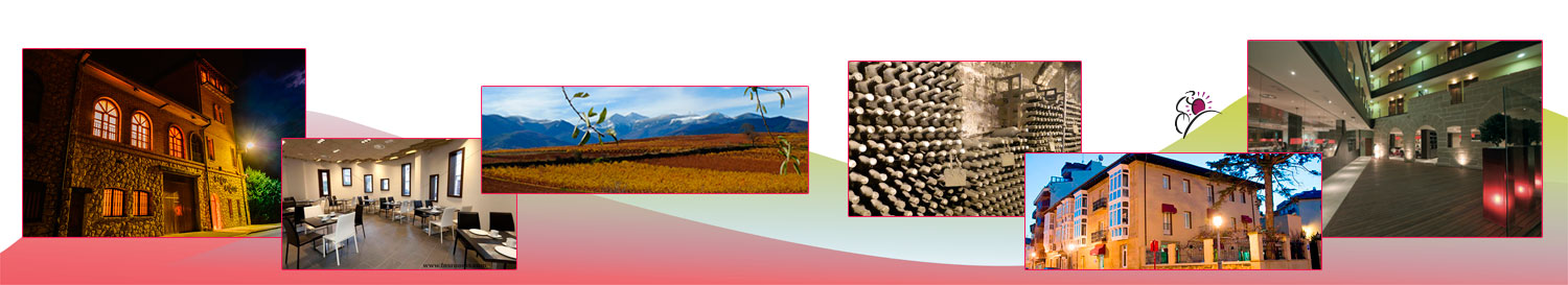
If you wish to see additional information or specific proposals in order to contract Self-Guided Packs for FUENTES del VINO MTB with all included service; hotels, luggage transport, etc. You can do it by entering this link.
If you have doubths, do not hesitate and use some of the buttons below, we respond quickly.
If FUENTES del VINO have interested you, it may also interest you